Project 1: Field Study
Building Aboveground Strategies to Identify and Address Belowground Hot Spots for VOC Vapor Intrusion in Complex Urban Settings
Rationale/Goal
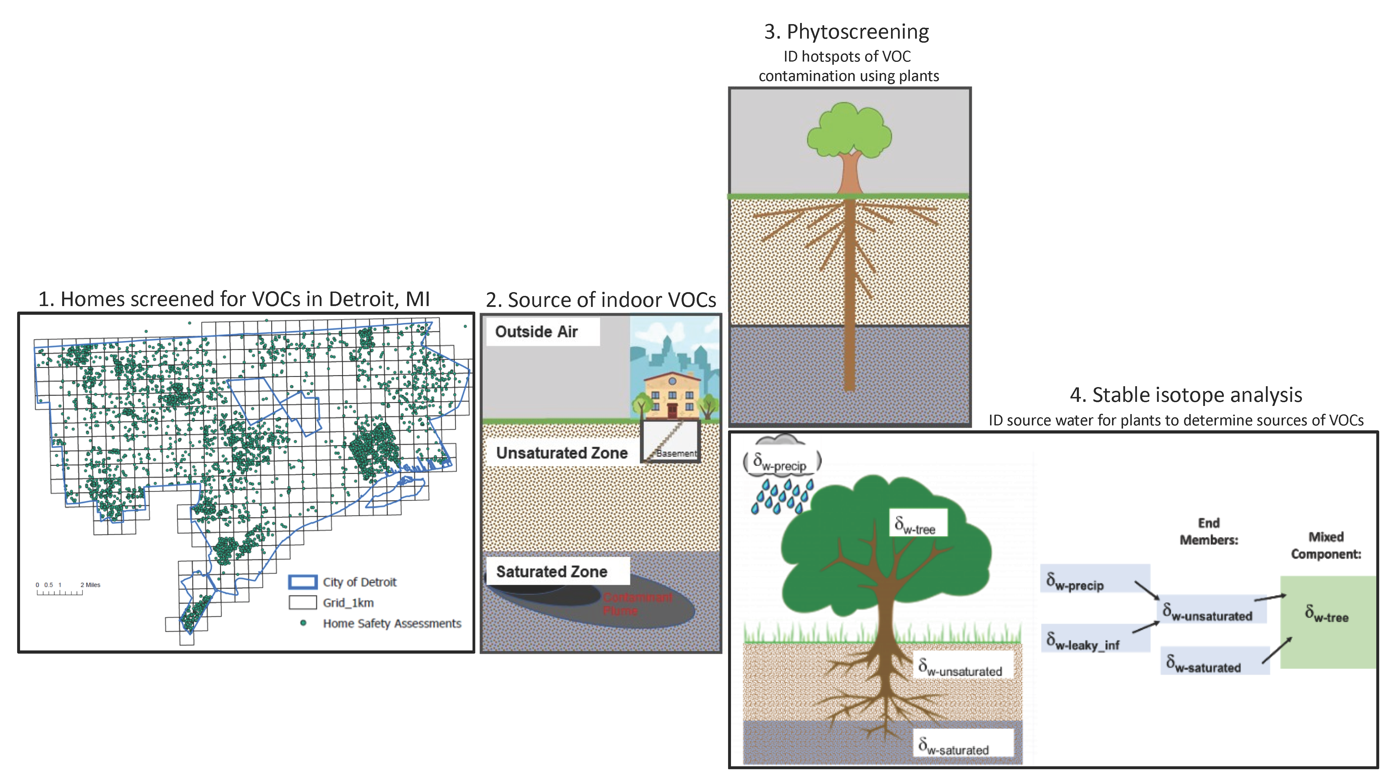
In post-industrial cities, volatile organic compounds (VOCs) are increasingly recognized as an especially problematic contaminant. VOCs have been highlighted because of their impact on public health through intrusion into basements via soil vapors. However, our ability to address this public health issue is limited by our ability to identify belowground VOC contamination in a spatially comprehensive and cost-efficient way. Our objective is to use an innovative aboveground approach to pinpoint possible hot spots of belowground VOCs in post-industrial urban environments contributing to human health issues associated with indoor air quality problems as a result of vapor intrusion. Our central hypothesis is that because VOCs can accumulate in plant tissue, mainly via root-water uptake, plant-water interactions can be used in a cost-effective way to inform VOC data and isolate belowground VOC hotspots in post-industrial urban environments with highly altered hydrology.
Methods
We propose to address this hypothesis through three specific aims:
- Identify hot spots of VOC contamination using data from aboveground plant tissue in a geospatial GIS framework
- Identify belowground source waters for urban plants to isolate possible sources of VOC contamination (especially in urban environments where access to groundwater through wells is limited)
- Verify belowground presence of VOCs and link to VOCs in indoor air
The proposed approach is the first effort to link phytoscreening and stable isotope techniques in understanding below- ground VOCs. Compounds of interests include trichloroethylene (TCE); tetrachloroethylene (PCE); and benzene, toluene, ethylbenzene, and xylenes (BTEX) priority Superfund contaminants that have been detected in soil vapors of our study area (Detroit, MI).
Expected Outcomes
Our findings will contribute to the problem-solving goals of CLEAR by:
- Providing the proof-of-concept for using aboveground plant tissue in both point and non-point belowground source remediation efforts of Superfund-relevant VOC contaminants in complex urban environments and
- Providing the geospatial framework for sharing data between environmental and biomedical research efforts aimed at improving conditions that impact public health in complex post-industrial urban environments.
Metrics from our geospatial framework and metrics of public health concern can be spatially correlated to focus remediation and/or mitigation efforts. Therefore, our project directly responds to SRP broad mandate 3, i.e. development of “methods and technologies to detect hazardous substances in the environment” and directly relates to the goals of CLEAR Project 2 (Sensing/Remediation Study). Our project also directly responds to SRP broad mandate 2, i.e. development of: “methods to assess the risks to public health presented by hazardous substances” because the incorporation of our environmental data into a geospatial framework allows for direct integration with public health data and directly relates to the goals of CLEAR Project 5 (Human Population Model) and the Community Engagement Core.
Project 1 Research Team
|
| Glen Hood, Ph.D. Assistant Professor, Biological Sciences Co-Investigator, Project 1, CLEAR, Wayne State University |
|
| Felice Gianluca Sperone, Ph.D. Assistant Professor (Teaching), Environmental Science & Technology Geospatial Data Analyst Co-Investigator, Project 1, CLEAR, Wayne State University |